
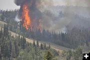
Torching
The Fontenelle Fire moved further into the Middle Piney drainage on Sunday, July 1st. The trees are 30-40 feet tall, giving perspective to how high the flames were. Photo by Great Basin IMT Team 5.
|
|
Fontenelle Fire update – Sunday night, July 1, 2012
47,478 acres, 5% contained, fire backburn diverts fire around Middle Piney summer homes, community meetings planned for July 2nd
by Great Basin IMT Team 5
July 1, 2012
Fontenelle Fact Sheet for Sunday, at 10:00 p.m.
Status: The Fontenelle Fire is burning on the Bridger-Teton National Forest, BLM High Desert District and State/Private Lands approximately 17 miles west of Big Piney, Wyoming. The fire began on June 24, 2012. The fire is currently burning in heavy, dead timber with occasional areas of grass and sage in the lower elevations.
Fire Statistics:
- 47,478 acres burned
- 5% contained
- 584 Personnel on scene
Community Meetings: The Incident Command Team will conduct public meetings Monday, July 2 at 5 p.m. at a location to be determined in Pinedale, and at 7:30 p.m. at the Latter-Day Saints church, 2250 Piney Drive, Big Piney. Times and locations can also be found at www.Inciweb.org.
Recent Events: The fire continued its progress northeast, spotting across Middle Piney road near the Forest Service boundary and pushing two miles north through sagebrush and grass to Johnson Ridge. A backburn on the timbered slope behind the Middle Piney vacation cabins successfully diverted the fire’s progress away from the cabins; however, the fire continued around the burnout and crossed Middle Piney road at Star Hill. Changing winds, very low humidity and high temperatures helped contribute 2,469 acres to the fire.
Today’s Strategy: Aerial support from helicopters operating from the Big Piney-Marbleton airport and heavy tankers from Pocatello, Idaho will be used to help firefighters try to contain the north-northeast fire boundary. Firefighters will continue to construct and improve fire line along the south-southwest portion of the fire area.
Forecast: The fire area will be under a Red Flag warning into the evening of July 2 due to high winds and low relative humidity.
Closures: Road closures at present extend from the forest boundary at the top of Bare Pass at Red Castles, west to N. Piney Meadows and Tri Basin Divide, south to Cheese Pass, Mount Isabel, and Red Park, east to the junction of LaBarge Creek Road and the forest boundary, and north to Bare Pass. The road closure on Middle Piney Road may move east depending on fire conditions. Further closures may be needed to ensure firefighter and public safety. The public is asked to be cautious when driving on the LaBarge Road between Hwy. 189 to the closure at the forest boundary as there may be large fire engines, fire traffic and impact from smoke.
More Information:
www.fs.usda.gov/btnf
www.inciweb.org
www.tetonfires.com
Twitter: @WildeType2_IMT
Fontenelle Fire information phone: 307-276-3324
Related Links:
Fire Restrictions
Expanded Closure Map
Fontenelle Fire photo gallery
|