
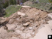
Road gone
Slide on the Moose-Gypsum Road in the Upper Green. View looking down the road towards intersection with Green River Lake Road. Pictures taken June, 2011. Photos by Kathy Raper.
|
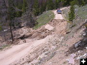
Moose-Gyp road slide
Slide on the Moose-Gypsum Road. View looking down the road towards intersection with Green River Lake Road. Photo by Kathy Raper.
|
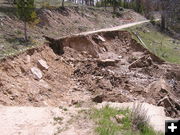
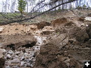
Up the road
Moose-Gyp road slide. June, 2011. Photo by Kathy Raper.
|
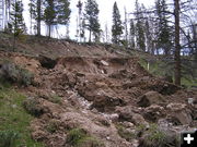
Up the slide
Looking up the slide towards the Moose Creek Road. Photo by Kathy Raper.
|
Slide
Looking up the slide towards the Moose Creek Road. Photo by Kathy Raper.
|
|
Update on BTNF roads and trails
As of Friday, July 1, 2011: High water, hypothermia danger in cold water, snow level at 8000 feet, some road closures due to slides
by Bridger-Teton National Forest
July 3, 2011
The Type 3 Incident Command team that has been managing the landslide and flood event for the Bridger-Teton National Forest is turning management back to daily District operations on Tuesday July 5th. However, the Incident Command team advises that high water will continue to persist beyond July 5th and new damage to roads and trails will likely emerge as snow melts out of the higher elevations. District personnel will continue to monitor roads and trails and will continue to provide weekly information updates to the public.
The snow water equivalent in the snowpack around Jackson is currently 878% of average according to the Natural Resources Conservation Service. Water levels in rivers and creeks have risen considerably this week in response to the warm temperatures. Peak water levels are expected to occur over the next few days. Many creek crossings are impassable right now due to the high water. Minor flooding is occurring notably on the Buffalo Fork near Moran.
Key Messages:
1. Public safety is our greatest concern. Floods are one of the most common hazards in the United States. Some floods develop slowly but flash floods can develop quickly, sometimes in just a few minutes. Search and rescue along with other emergency responders will be stretched thin so preventing the need for rescue is paramount.
2. Conditions are changing rapidly. Prior planning and preparation is critical to ensure a safe and enjoyable trip to the National Forest. Visitors are strongly advised to check current conditions before arriving for a visit.
3. Information is available and will be updated regularly. Check the websites listed below or contact the Forest Service at (307) 739-5500
4. Recreation opportunities are available on the National Forest. Information on some of these opportunities is listed below.
Closures: A temporary closure remains in effect for some Forest roads in the Jackson area. Closed roads include Mosquito Creek, Dog Creek, Little Granite Creek, upper Sheep Creek road, and Cottonwood / Fish Creek roads in the upper Gros Ventre. On the Big Piney Ranger District the Upper Hoback Road (#30700) is closed beyond the junction with Forest road #30059. On the Buffalo Ranger District, an area closure has been implemented between Togwotee Lodge and the Four-mile road north of the Togwotee highway due to prevent potential encounters between people and a grizzly bear with cubs.
Road Conditions: Forest Roads on the Jackson and Buffalo District are generally open except where road damage is necessitating continued closures. Road work on Mosquito Creek was delayed due to a more pressing problem on the Green River Lakes road. Road crews expect to finish work on Mosquito Creek road next week with the road opening by Thursday. Be aware that lingering snow and downed trees could still be encountered on some roads. The Fall Creek road is open but there is a 12 ton load limit on the bridge. Forest visitors are reminded to comply with closure signs to prevent damage to road surfaces and ensure safety. Closed roads are open to non-motorized uses.
River Conditions: The Snake River is open. Boaters are advised to stay river right in the vicinity of the Double Draw landslide due to a stringer in the river. Water levels have increased considerable due to the warmer temperatures. The Alpine gage is currently recording 26,000 cfs and may increase more over the coming days. High water levels, fast currents and floating debris such as large trees continue to be safety concerns for those looking to recreate on or near the river. River features are changing with the high water and floating trees and debris are lodging against bridges and natural features. Hypothermia is a very real threat for any boater ejected from a boat. Boaters are strongly advised to thoroughly check conditions before getting on the river, build in an extra margin of safety, wear approved life jackets, be prepared for self-rescue, and go with BTNF permitted outfitters. WYDOT contract work on the Blue Trails Slide will begin July 11th causing 20 minute delays on Highway 26/89.
Campgrounds: All campgrounds on the Jackson and Buffalo Districts are now open. Granite Hot Springs is also open after a brief closure on Tuesday June 28th for spraying trees to prevent bark beetle mortality. Campers in the Snake River Canyon are advised that work in the landslide area will create noise. Visitors are advised to check with local district offices for specific conditions on the Grey’s River, Big Piney, Pinedale, and Kemmerer Districts. Campers are reminded that water levels will be high over the forth of July weekend. Fast-moving, cold water can be dangerous. Be safe by keeping yourself, children and pets away from streams and rivers.
Trail Conditions: Trails above 8,000 feet remain under snow. Trail users are strongly advised to plan trips to avoid creek crossings. Creeks have risen considerably with the warm temperatures and many creek crossings are simply not possible right now. Volunteers recently completed significant improvements in Munger Mountain. These trails are open to motorcycle use July 1st as well as open for non-motorized trail use. In the Greater Snow King area, a bridge and trail re-route was recently finished on the Game Creek trail to fix a significant problem. In the Teton Pass area, lower elevation trails are open but snow and very wet conditions still exist in the upper elevations. The Arrow trail still has 3 feet of snow in places and the upper portions of History trail, Black Canyon and Phillips Canyon are still snow covered. In the Gros Ventre and Shadow Mountain area, trails open to motorized use July 1st, however be aware that creek crossings may limit access. The Horsetail Creek is still snow covered on top and water is running down the trail so motorcyclists are advised to give this trail more time to dry. Forest Service crews have also recently cleared the lower portions of trails in the Snake River Range. Trail crews are seeing bear tracks and some mountain lions have been sighted, so be alert, keep dogs well within sight, and carry pepper spray. Baby animals are starting to appear. Give mom and her calf plenty of space and leash you dog if you see a baby animal.
More Information: Please visit http://www.inciweb.org for more information and related links through the weekend. Information will no longer be posted on this website after July 4th. Bridger-Teton National Forest Information: (307) 739-5428
|