
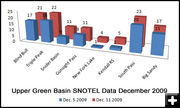
SNOTELS
SNOTEL snow depths for the Upper Green River Basin.
|
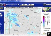
Snow Cover
Sparse snow cover for western Wyoming on Friday, December 11, 2009.
|
|
Winter Storm Watch for western Wyoming
From 6 to 20 inches of snow possible over the weekend
December 11, 2009
The National Weather Service out of Riverton has issued a Winter Storm Watch from late Friday through Sunday afternoon. A Pacific winter storm will move into western Wyoming late Friday with light snow developing after midnight. By sunrise steady widespread snow is expected to develop. Periods of snow are then expected Saturday, Saturday night and Sunday tapering off Sunday evening.
Snow accumulations of 12 to 20 inches can be expected in the mountains with locally heavier amounts. Visibility from one half to one quarter of a mile can be expected with periods of near zero visibility.
The Upper Green River Basin foothills and Pinedale are expected to get snow accumulations of from 6 to 12 inches, with locally heavier amounts.
Travel will become difficult with snow-packed roads and poor visibility. Travel over the mountain passes will become difficult with snow packed roads and poor visibility. People planning outdoor activities should be prepared for heavy snow bitter cold wind chills and poor visibility.
Weather Forecast:
Friday Afternoon: Mostly sunny, with a high near 17. South southwest wind around 8 mph.
Friday night: A 30 percent chance of snow after 11pm. Increasing clouds, with a low around -2. Wind chill values as low as -15. South southeast wind around 8 mph becoming north northwest.
Saturday: Snow. High near 26. Wind chill values as low as -15. North wind 6 to 11 mph becoming south southwest. Chance of precipitation is 90%. New snow accumulation of 2 to 4 inches possible.
Saturday Night: Snow. Low around 14. Wind chill values as low as -5. South wind around 11 mph. Chance of precipitation is 90%. New snow accumulation of 2 to 4 inches possible.
Sunday: Snow. High near 29. South southeast wind 10 to 14 mph becoming west southwest. Chance of precipitation is 90%. New snow accumulation of 3 to 5 inches possible.
Sunday Night: A 50 percent chance of snow. Cloudy, with a low around 12. West wind around 15 mph, with gusts as high as 22 mph.
Monday: A 50 percent chance of snow. Mostly cloudy, with a high near 28. Breezy, with a west wind between 13 and 20 mph, with gusts as high as 28 mph.
Monday Night: A 20 percent chance of snow showers. Mostly cloudy, with a low around -3.
Tuesday: Partly sunny, with a high near 31.
Tuesday Night: Partly cloudy, with a low around -1.
Wednesday: Mostly sunny, with a high near 33.
Wednesday Night: Partly cloudy, with a low around 2.
Thursday: Mostly sunny, with a high near 33.
Click on the links below for more information on area road conditions, weather and web cams:
www.weather.govr National Weather Service (NWS)
Road Closures & Advisories Wyoming Department of Transportation (WYDOT)
Travel Condition map WYDOT
SW Wyoming Travel Conditions WYDOT
Pinedale area Road & Weather Info Pinedale Online!
|