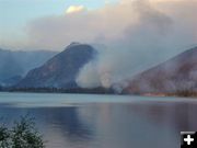
Pinedale Online!
www.PinedaleOnline.com
www.Pinedale.com

Pinedale on the Web!
Pinedale, Wyoming

Home | Calendar of Events | Photo Gallery | Local Businesses |

Pinedale Online > News > August 2008 > New Fork Lakes Fire grows to 11,585 acres

New Fork Lakes fire. Photo by Chris Havener.
New Fork Lakes fire
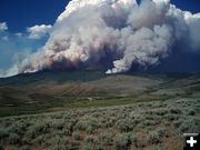
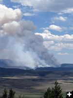
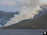
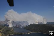
Aerial view of the fire showing New Fork Lakes and the Narrows. View looking northeast into the New Fork drainage. Photo by Chris Havener.
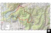
Fire Map August 3. Photo by US Forest Service.
Fire Map August 3
New Fork Lakes fire perimeter map as of Sunday, August 3. The fire is 11,585 acres.

Scroll down for more photos.
New Fork Lakes Fire grows to 11,585 acres
Area trail closures in effect
by Pinedale Online!
August 4, 2008

TRAIL CLOSURES: Bridger-Teton forest officials have issued an area closure for the New Fork Lakes Fire. Trails included in the closure are New Fork Lakes, Willow Creek, Spring Creek, and Long Lake.
__________________________________________

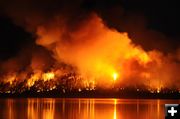
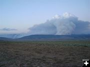
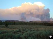
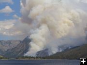
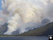
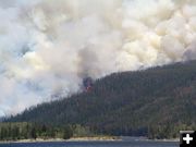
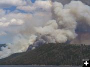
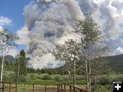
The New Fork Lakes Fire grew to 11,585 acres, as of Sunday night, August 3rd. The fire has been burning since Tuesday, July 28th. The human-caused fire started due to an abandoned campfire on the southeast shore of the lake. The blaze is about 19 miles north of Pinedale, burning mostly east in the Bridger Wilderness. It is burning in decadent stands of timber and bug-kill lodgepole pine, and the growth potential remains high.

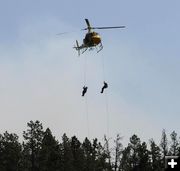
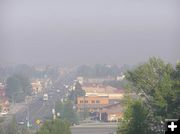
Wilderness rangers are working the area ahead of the fire to make contact with anyone in the area to make them aware of the trail closures and have them vacate the area. The fire has been putting up a huge column of smoke, visible from a long distance. Signs are posted at the trailheads to warn of the trail closures.

Fire crews have gained 9% containment of the fire. Firefighters are patrolling the holding lines and providing structure protection for residences, outbuildings and ranches in the vicinity west of the blaze. There are currently 162 total personnel on this fire.

For current updates online, see the Inciweb page for this fire: http://www.inciweb.org/incident/1440. Click on the Photos and Maps links for current maps showing the fire perimeter and many photos of the fire.
______________________

Special thanks to Debbee Miller, Sally Hayward, Kirby Hedrick, Bob Rule/KPIN Radio, and US Forest Service for the recent photos of this fire. See our Pinedale Online story archive for earlier updates and many more photos of this fire (look through July and August).


Lozier's Box R Ranch. Photo by Debbee Miller.
Lozier's Box R Ranch
View showing the fire with Lozier's Box R Ranch in the foreground. Photo by Debbee Miller, taken on Saturday, August 2.

Rappelers. Photo by US Forest Service.
Rappelers
Firefighters rappel from a helicopter. US Forest Service photo.

Firestorm. Photo by Chris Havener.
Firestorm
Photo by Chris Havener.

Inversion. Photo by Dawn Ballou, Pinedale Online.
Inversion
The smoke inversion is clearly visible below the Wind River Range early on Monday morning, August 4. The inversion typically lifts as the day progresses and winds pick up to clear the smoke out. View looking at the Wind River Range as seen from Big Piney. South county was clear and free of smoke when this photo was taken around 7AM.

Pinedale smoke August 4. Photo by Bob Rule, KPIN 101.1 FM.
Pinedale smoke August 4
View of smokey Pinedale around 6AM on Monday morning, August 4. Photo by Bob Rule, KPIN 101.1 FM.

Fire August 2. Photo by Sally Hayward.
Fire August 2
New Fork Lakes fire on Saturday, August 2. Photo by Sally Hayward.

Fire Moving East. Photo by Sally Hayward.
Fire Moving East
View looking east at the Wind River Range. The New Fork drainage is on the left. The fire is moving east into the Willow Creek drainage, in the Bridger Wilderness. Photo by Sally Hayward, taken Saturday, August 2.

Smoke Column. Photo by Sally Hayward.
Smoke Column
Fire on Saturday, August 2. Photo by Sally Hayward.

Fire August 1. Photo by Kirby Hedrick.
Fire August 1
Fire on Friday, August 1. Photo by Kirby Hedrick.

Air Health Alert. Photo by KPIN 101.1 FM.
Air Health Alert
Morning air inversions caused smoke from area fires to settle over the Upper Green River Valley and Pinedale. Sublette County Health Officer Dr. Tom Johnston issued Air Health Alerts in the mornings since August 1st advising people with compromised breathing capacity to stay inside and avoid physical activity. The smoke cleared each day as winds picked up and blew it out, cancelling the health alerts.

July 30 fire. Photo by Pinedale Online.
July 30 fire
View of New Fork fire on Wednesday, July 30, across the lake from the Narrows.

Along the lake. Photo by Pinedale Online.
Along the lake
New Fork Lake fire on Wednesday, July 30.

View on Tuesday July 29. Photo by Pinedale Online.
View on Tuesday July 29
View from New Fork Lake on Tuesday, July 29.

Narrows Flames. Photo by Pinedale Online.
Narrows Flames
Fire on Tuesday, July 29, showing flames and the fire crowning in trees on the ridge along the shoreline near the Narrows.

July 29. Photo by Pinedale Online.
July 29
View of fire near New Fork Lake on Tuesday, July 29.

Billowing Smoke. Photo by Pinedale Online.
Billowing Smoke
View of smoke column from the Boy Scout camp at New Fork Lake on Tuesday, July 29.
  
Pinedale Online > News > August 2008 > New Fork Lakes Fire grows to 11,585 acres

Pinedale Online!
Pinedale Online! PO Box 2250, Pinedale, WY 82941
Phone: (307) 360-7689 or (307) 276-5699, Fax: (307) 276-5414

Office Outlet in Pinedale, 43 S. Sublette
E-mail:support@pinedaleonline.com

Copyright © 2008 Pinedale Online. All rights reserved.
Pictures and content cannot be used in whole or part without permission.