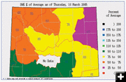
Wyoming Snowpack 80% of normal
Green River Basin 74-108% of average
March 13, 2005
Overall, Wyoming snowpack is currently about 80% of average for March, according to the March 1, 2005 Wyoming Basin Outlook Report by the Natural Resources Conservation Service (NRCS). In general, snow water equivalent (SWE) across Wyoming is well below average for this time of year. Early storms covered Wyoming with snow, but very little snow has fallen since late November.
The northeast portion of the state is currently the driest at 65% of average. Southwest Wyoming is looking good at 96% of average for this time of year. Southeast Wyoming is presently at 88% of average and northwest Wyoming is 70% of average.
Hydrologists measure mountain snowpack through manual snow courses and automated SNOTEL sites in order to monitor snowpack conditions throughout the winter and to make summer runoff forecasts. Precipitation for February varied from 13-63% of average across the state, although localized averages range from 64-105% of average. In general, the southwest portion of Wyoming is looking the best for current water conditions.
Wyoming is doing much better in overall snowpack than the state of Montana to the north, which had a state-wide mountain. precipitation of 37% of average. According to the Natural Resources Conservation Service (NRCS), February was the fifth month in a row with below average precipitation in Montana. Forecasters predict significant surface water shortages in all areas of Montana unless there are major increases in spring and summer precipitation.
Snowpack
Snow Water Equivalent (SWE) for the Snake and Green River Basins is below average. Jackson Lake is 67% of average, slightly better than this time last year. SWE in the Upper Green Basin above Warren Bridge is 74% of average. The New Fork River Basin is 93% of average. Big Sandy/Eden Valley is one of the few spots above average at 108% SWE. The Hoback River drainage is 71% of average, down 10% from this time last year. The Greys River drainage is also down a bit from last year, currently at 78% of average. Above Palisades, SWE is 71% of average.
Precipitation
Last month's precipitation was well below average across all of Wyoming. The Belle Fouche & Cheyenne River Basin was the lowest percentage basin for the month at 37% of average. The Little Snake River was 87% of average for the highest percentage basin for the month.
The lower end of the Green River Basin is doing better this year than in the past several years. The Big Sandy area of the west side of the southern Wind River Mountains has been receiving better precipitation and is at 108% of average. Hams Fork, Black Fork and Henry’s Fork Basins are presently over 100% of average snowpack. The Green River Basin above Flaming Gorge is 91% of average. Further south, the Upper Bear River Basin in Utah is currently 118% of normal for SWE.
Streamflow
Stream flow yield is expected to be well below average across Wyoming, around 75% of average. Below are current predictions for April through July run-off for selected area streams:
Pine Creek above Fremont Lake: 87% of average
Green River at Warren Bridge: 83% of average
New Fork River near Big Piney: 82% of average
Fontenelle Reservoir inflow: 79% of average
Big Sandy near Farson: 100% of average
Reservoir outlook
Basin reservoirs are looking bleak for some and great for others, varying from 51% to 171% of average. Reservoirs in the Wind River Basin are average or above average. Green River basin reservoirs are only slightly below average. On the eastern side of the state, reservoirs are below average. Forecast runoff is 49-115% across Wyoming.
Reservoir storage is improved from last year. Current storage rates are as follows:
Jackson Lake storage: 29% of average.
Palisades reservoir storage: 61% of average.
Big Sandy Reservoir: 60% of capacity.
Fontenelle Reservoir: 94% of average and 43% of capacity.
Flaming Gorge: 95% of average
Viva Naughton: 72% of average
Drought conditions
The National Weather Service says “moderate to severe hydrologic drought continues for western and southwestern Wyoming and north central Wyoming. Within the last four to six weeks, hydrologic drought conditions have been downgraded to extreme. Little improvement is expected in drought conditions through May.
Spring runoff flooding forecast
The National Weather service expects most of Wyoming to have below normal spring runoff volumes. Flooding isn’t expected to occur due to dry soil moisture conditions as well as decreased outflow releases from the low reservoirs. Some smaller headwater basins may see significant rises, however infiltration and percolation will likely intercept a lot of the available water and overland flow. The notable exception to this is the Sweetwater drainage, where stream flows are expected to be well above normal.
|